Local heating and cooling planning – What benefits?
Learn from the Hotmaps pilot cities’ experience
About

In the past 4 years, five members of the Energy Cities’ network co-developed and tested the Hotmaps toolbox for heating and cooling (H&C) planning together with leading research institutions in Europe. The final version of this software and support materials are now fully available online, for local authorities willing to kick-off or simply improve their strategic heating & cooling planning.
What is strategic H&C planning?
The aim of strategic energy planning, including heating and cooling planning, is to promote the transition to a more flexible integrated energy system with focus on energy efficiency and renewable energy. In most European cities and regions, there is a need to better identify, analyse and map resources and solutions to make energy demand more efficient on one hand and to meet the demand with efficient, cost-effective and greener energy sources on the other hand.
Strategic heating & cooling planning means developing an action plan to achieve a long-term vision of the heating and cooling supply. To get there, there are usually the following steps:
1- Analyse the challenges, formulate strategic objectives and identify key parameters;
2- Build scenarios based on cost-effective technical solutions from a societal perspective;
3- Evaluate existing framework and identify key stakeholders;
4- Make an action plan
Our new publication “The Hotmaps Toolbox – Supporting strategic heating & cooling planning at local level” will guide you through each step.
H&C planning with Hotmaps
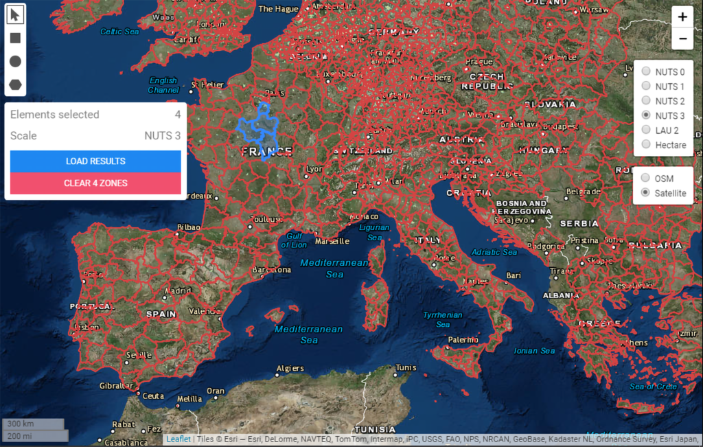
The Hotmaps software was developed to support public authorities in this process. It allows browsing through a European map and retrieving information on space heating and hot water demand, CO2 emissions as well as potentials for renewable energy supply like solar energy on a spatially disaggregated level. Users can select their regions and geographical scale of interest, with data available for all EU countries, UK and Switzerland. For a more detailed analysis, they may also upload their own data in their private user accounts.
What benefits?
The municipalities of Bistrita (Romania), Frankfurt (Germany), Geneva (Switzerland), Milton Keynes (UK), Donostia San Sebastian (Spain), Aalborg (Denmark) and Kerry County (Ireland) were at very different stages of their planning when they joined the EU funded project Hotmaps as pilot areas, but all found the toolbox very useful.
For example, already in 2005, the City of Geneva committed to become 100 % renewable by 2050 and gradually transition from fossil fuels to renewable energies. To implement this vision, the City has developed an energy policy focused primarily on its 800 municipal buildings and wants to develop a plan focusing on existing buildings and districts as well as on the largest consumers. According to Etienne Favey, Energy Manager for Geneva’s municipality: “We quickly realized that we lacked a planning tool to first, identify local energy resources and second, adapt them to urban development and the high concentrations of energy consumed throughout the municipal territory. Hotmaps brought real and important benefit to the planning process, especially for the discussion with stakeholders.”
In Frankfurt am Main, district heating was already one of the key pillars of the sustainable energy action plan. The city has the overall ambition to reduce GHG emissions by 95% in 2050 compared to 1990! The calculations performed with the Hotmaps toolbox confirmed that in order to reach the city’s goal, a reduction of heat demand in buildings between 40% and 50% is needed. Thanks to Hotmaps, they also identified the most cost-efficient renovation rate to be coupled with locally sourced heat and reinforced their cooperation with the local utility company.

For San Sebastian and Bistrita, the project was an interesting opportunity to begin heating and cooling planning process and develop their first strategy. For example, thanks to Hotmaps-based calculations, Bistrita discovered the potential of using local biomass and excess heat from its wastewater treatment plant and from the river. They intend to talk with the citizens about the development of a local district heating network and change the negative image that this technology has in Romania.
Read more about the Hotmaps pilots areas’ experience
But Hotmaps is not only useful to plan heating and cooling networks. According to Jeremy Draper, working for the municipality of Milton Keynes: “It has been useful to identify and verify additional resources in our area, not just for heating/cooling networks, but other sources of locally generated energy.” The heat strategy developed by the city during the Hotmaps project aims at helping planners but also private developers to identify opportunities and trigger investments.
How to use Hotmaps?
In order to make Hotmaps an accessible one-stop-shop, the project team has made support materials in form of video tutorials, handbooks and a Wiki available online in different languages.
Live trainings (in person and online) took place in 2019 and 2020. They allowed many European cities and public entities to familiarise themselves with the toolbox, receive support from the Hotmaps developers and researchers, but also to provide valid feedback to improve the toolbox. The training materials developed during the project are also available to anyone willing to learn how to use it. Step-by-step exercises have been designed to allow a fast and easy understanding of the calculation modules. Supporting documents are also provided, such as videos and calculation spreadsheets.
Curious to discover Hotmaps and start developing your H&C strategy? You can use it for free! Give it a try and learn more about your local energy sources!