Understanding, planning and combating urban heat islands
Cities are adapting to climate conditions and taking action to bring down local temperatures.
About

With summer approaching, we all remember the high temperatures that we have suffered in recent years.
Energy Cities has tested several possible solutions: creating draught, keeping rooms dark, putting on a fan blowing through a wet towel, putting our feet in a tub of water… And still, it remained challenging, the only upside of remote work was the ability to retreat to the countryside and enjoy the shade of trees in the garden or the coolness of old houses.
But how were things for our colleagues who remained in the city? What solutions are available to cool down homes and overheated plazas where the heat builds up throughout the day?
And at a higher scale, European cities are also facing this phenomenon. Some of them are implementing measures to avoid heat islands and lower the temperatures within city limits.
1 million trees in Bordeaux
The City of Bordeaux worked to better understand these phenomena before drafting an action plan.
A study identified these heat islands and recommended measures. A total of 34 initiatives were drawn up, addressing issues including urban design, the role of vegetation and water in the city and architecture.
In addition to these measures, the city recently launched a large-scale local revegetation operation, which will transform it from a very mineral city into a greener, more pleasant city in the next few years.

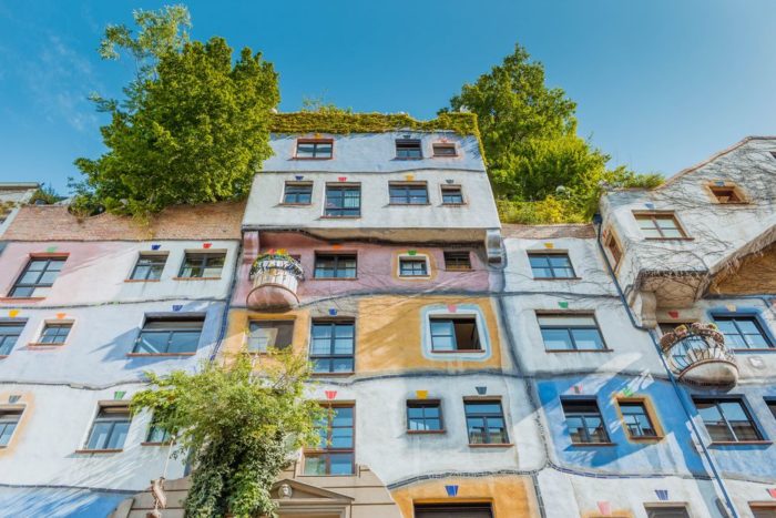
Strategic plan in Vienna
The city of Vienna worked alongside scientific experts and municipal services to build an Urban Heat Island (UHI) plan that details various options to bring down temperatures in the city’s heat islands. Many of the measures described in this strategic plan have already been implemented in order to reach the goal of making the city more liveable as we face the consequences of climate change.
One of these measures was to set up green infrastructure to reduce the heat island effect. Green corridors have been planned within the city to increase interactions between green areas, increase ventilation and cool the air. These measures cover buildings, with facades and roofs undergoing revegetation.
These measures improve the production and distribution of cool air. Connecting these cooling zones to the dense city centre, using networks aligned with dominant winds, helps improve ventilation in the city centre.
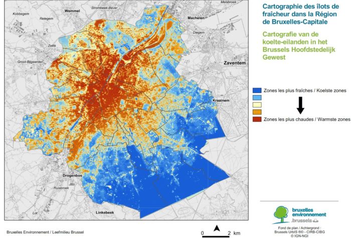
Mapping islands in Brussels
Brussels has recently ordered a study to be able to visualise heat islands and cool areas on its territory.
This map has been uploaded to the city’s website, where local residents can quickly identify cooler areas to go to on very hot days. It also highlights the heat islands to be prioritised for cooling measures.
This study once again shows how important green spaces are in urban areas.
In 2019, the city launched the Canopy revegetation plan, which will diversify plant species and plant urban forests over a 10-year period (2020–2030). This plan will help cool and purify air, while also preserving biodiversity.